Part 1: Preparations
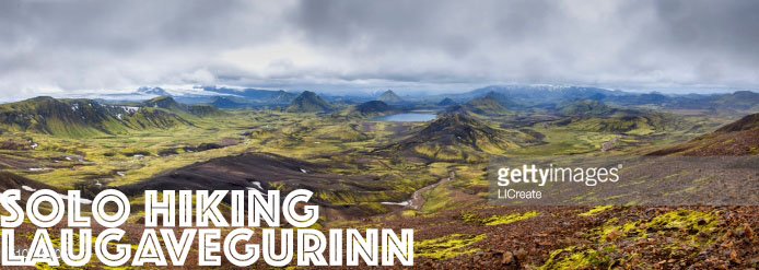
It’s been a busy summer, as most summer are. Usually I am lucky to get in one backcountry hike between June and November, but this year I am aiming for three! With a two day Blow Me Down Traverse completed, next up is hiking Laugavegurinn in Iceland! Laugavegurinn means “the hot spring route” in Icelandic. This route spans about 53 kilometres from Landmannalaugar in the north to Thorsmork in the south.
This trek opportunity came up very organically. Wild Women Expeditions just launched our new Ultimate Iceland Adventure and it works out that I will have time to hike the trail between the two Golden Circle Riding Adventures I’m supporting this month. Needless to say I am STOKED!
And it will be my first solo hike.
Am I a bit nervous? Of course. But I know I have the fitness and skills to pull off this 53km trek in 3 days. It’s like doing anything by yourself for the first time, you feel unsure, perhaps even have traces of doubt. But deep down, I know I’ve got this!
With my plane tickets and travel medical insurance booked via Flight Centre back in April, I was able to get to Iceland from Deer Lake, Newfoundland very easily via Halifax using Westjet and Iceland Air for about $1200 Canadian.
I spent less than 12 hours preparing using this Multiday Trek Checklist, less a few items due to international travel and Iceland import regulations. Then I used my Multiday Day Menu Plan to buy and pack the food needed for the five days I will be travelling and trekking. Yes, I bought my food and prepackaged it, packing it with me to Iceland. It was much cheaper and easier to organize in my kitchen! Check here for food import regulations for Iceland.
Once I land in Iceland, I will purchase my Bus Tickets, find out where to buy the last few groceries and get a Topo map of the trek area. With my route plan complete, I just have to count down the days to start hiking Laugavegurinn!
ROUTE PLAN
AUG 25TH: Reykjavik – Landmannalaugar
Itinerary
- 1pm – Arrive BSI
- 4pm – Reykjavik Excursions bus #11 departs to Landmannalaugar (GPS 63°59.600 – 19°03.660)
- 7:30pm – Arrive Landmannalaugar, set up camp
- 8:50pm – Sunset
Overnight
- Camping at Landmannalaugar Hut (kr1800/ ~$20)
AUG 26TH: Landmannalaugar to Álftavatn
- TOTAL DISTANCE: 24km
- EST. HIKING TIME: 8-10 hours
- ELEVATION: +470 meters, then -490 m
Itinerary
- 5:56am – Sunrise
- 7am – Depart Landmannalaugar (GPS 63°59.600 – 19°03.660). Heading southwest, the trail goes through a rough lavafield “Laugahraun”. From there on up the slopes of “Brennisteinsalda” and to the plateau. The view offers an incredible spectrum of colours. After 3 – 4 hours you arrive at “Stórihver”, a hot spring and almost the only green spot visible in the first day.
- Lunch at Hrafntinnusker Hut (GPS 63°55.840 – 19°09.700)
- Then through a valley with some small ravines but be careful as they may be filled with snow. The trail down the “Jökultungur” is rather steep but leads down to a friendly oasis on the banks of river “Grashagakvísl” a fine place to rest for a while. From there on the trail to the two huts by the lake “Álftavatn” is on flat land. There are two huts (GPS 63°51.470 – 19°13.640).
- 9pm – Sunset
Overnight
- Camping at Alftavatn Hut (kr1800/ ~$20)
AUG 27TH: Álftavatn – Emstrur/ Botnar
- TOTAL DISTANCE: 15km
- EST. HIKING TIME: 6-7 hrs
- ELEVATION: -40 m
Itinerary
- 6am – Sunrise
- 8am – The trail heads over the ridge “Brattháls” into “Hvanngil” ravine, then wading across the river “Bratthálskvísl”. In “Hvanngil” are two huts here. A short walk from the huts is the river “Kaldaklofskvísl” with a bridge for hikers. On the eastern bank heading southwards at the fork to “Emstrur”. Less than one km from “Kaldaklofskvísl” another river has to be waded. Then approximately 4 km further another river “Nyrðri Emstruá” with a bridge.
- 4pm-6pm – Arrive at the huts in “Botnar” (GPS 63°45.980 – 19°22.480). Evening walk to the “Markarfljótsgljúfur” canyon.
- 9pm – Sunset
Overnight
- Camping at Emstrur (kr1800/ ~$20)
AUG 28TH: Emstrur (Botnar) – Þórsmörk
- TOTAL DISTANCE: 15km
- EST. HIKING TIME: 6-7 hrs
- ELEVATION: -300 m
Itinerary
- 6am – Sunrise
- 8am – Go around the canyon of “Syðri – Emstruá” to the very steep path down to the bridge. Then a walk through the area known as “Almenningar” with crossing of among other rivers “Þröngá”. After crossing “Þröngá”, it’s about 30 minutes to the hut in “Langidalur” in “Þórsmörk” (GPS 63°40.960 – 19°30.890)
- 9pm – Sunset
Overnight
- Camping at Langidalur/Thorsmork (kr1800/ ~$20)
AUG 29TH: Thorsmork-Reykjavik
Itinerary
- 7:20am – Depart Thorsmork/Langidalur on bus 9A
- 11:05am – Arrive at BSI Bus Terminal/Reykjavik
Share a solo trekking tip in the comments below!
Share the Adventure!


